
Many Wonderful Places to Explore in Zion National Park
There is a lot of hype about hiking Angels Landing and The Narrows, and they are great for thrill seekers. But there are many other wonderful places to explore in Zion National Park meant for people of all ages.
Utah’s most popular park boasts a vast array of sandstone cliffs, mountain peaks, natural rock arches, towering waterfalls, and diverse wildlife. The stunning and distinct beauty throughout the park is why millions flock to see Zion each year.
Yet, it is the Virgin River that is the star as it continues to carve and shape the canyons throughout the park.
Virgin River Continues to Shape Zion National Park
Zion became a national park in 1919. Its Virgin River was designated a Wild and Scenic River in 2009.
The Virgin River drops a whopping 7,800 feet over 160 miles of travel, according to the Zion website. It cuts through the sandstone and is continually carving the canyons, making Zion the park we know today.
The river forks north and east of the park. The North Fork Virgin River begins at Cascade Falls, which drains from Navajo Lake at 9,000 feet above sea level. The East Fork Virgin River begins above Long Valley. Both the north and east forks go through the park and empty into Lake Mead, west of Las Vegas, at around 1,000 feet above sea level, where they join the Colorado River. Rivers and Streams – Zion National Park (U.S. National Park Service)

Through Zion National Park, the river drops 71 feet every mile, compared to the Mississippi River dropping about an inch per mile, notes the website. Most of the year the river flows an average of 100 cubic feet per second, transporting a million tons of sediment per year, the park states. Yet, when there is flooding, the park website notes the river can swell to thousands of CFS carrying boulders and trees.
This is why being weather aware is important.
The river isn’t the only beautiful place to explore at Zion National Park. There are scenic drives to cruise, night skies to observe, trails to hike, and roads to bike.
Zion-Mount Carmel Highway
In some areas of the park, you don’t even have to get out of your car—but I suggest you do.
The 25-mile drive on the east side along Zion-Mount Carmel Highway is full of amazing rock formations, tunnels, switchbacks, and, if you are lucky, wildlife.
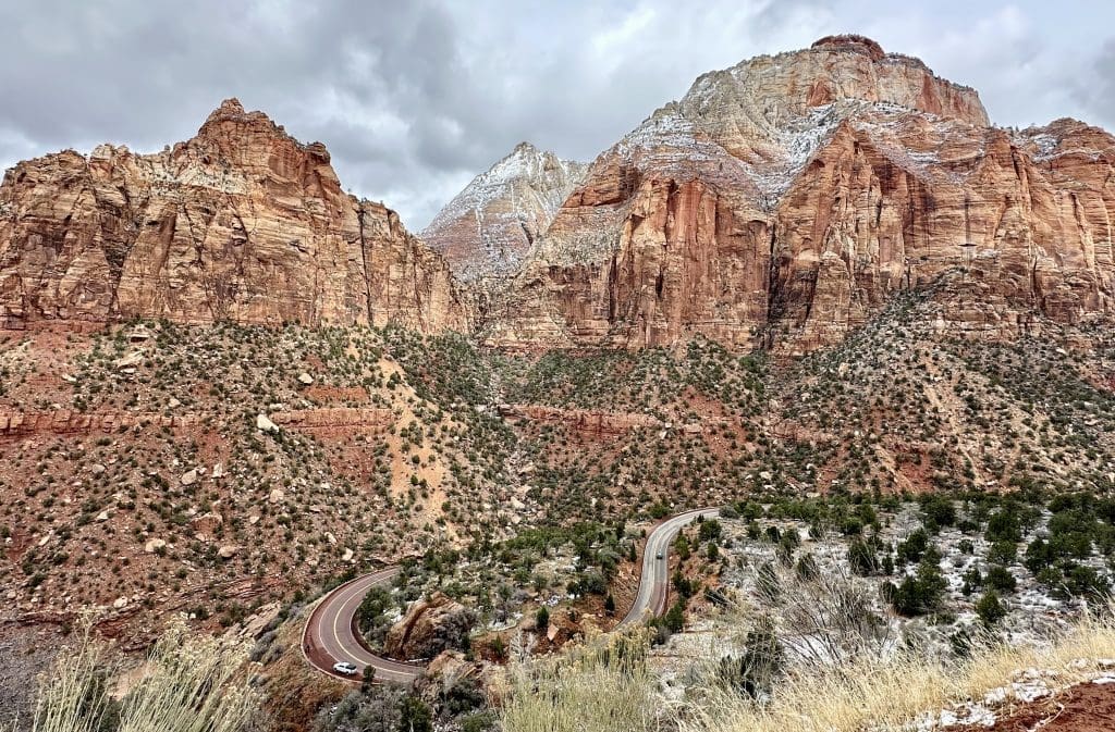
From Zion Canyon, the highway travels up the switchbacks through Pine Creek Canyon, the Navajo sandstone cliffs, then across the slickrock. Zion-Mt. Carmel Highway and Tunnel History – Zion National Park (U.S. National Park Service)
There are two tunnels on this stretch of the road but one is much shorter than the other.
The other, a 1.1-mile tunnel, dedicated in 1930, is a Historic Civil Engineering Landmark by the American Society of Civil Engineers. Zion-Mt. Carmel Highway and Tunnel History – Zion National Park (U.S. National Park Service)

You are more likely to see desert bighorn sheep between the tunnels and the east entrance climbing on the slickrock.
Another interesting landmark is Checkerboard Mesa which is close to the park’s east entrance. I found it to be even more beautiful after a snowstorm.

It looks like a checkboard due to the horizontal crossbedding from ancient sand dunes and vertical cracking from the expansion and contraction, states a park sign.
Hike the Watchman Trail
My first recommended hike, near the visitor center, is the Watchman Trail. The 2.8-mile round-trip Watchman Trail, with 368 feet of elevation change, provides views of Temple and Towers, lower Zion Canyon, and Watchman Peak. Zion Canyon Trail Descriptions – Zion National Park (U.S. National Park Service)

Even with clouds hanging low during our hike, the views on the Watchman Trail were amazing. And if you like cacti, you’ll be delighted to see so many. The moderate hike features minor drop-offs, and you’ll walk partly under rock formations, which make for unique scenery.
Beside this hike, you can see Watchman Peak from various vantage points, including the road and behind Cable Mountain Lodge near the south entrance.
Admire the Court of Patriarchs
Zion Canyon Scenic Drive has several places to explore at Zion National Park, including the towering peaks of the Court of Patriarchs.

The mountain peaks in the Court of Patriarchs were named after the Old Testament figures Abraham, Isaac, and Jacob, each over 6,800 feet, according to a park sign. The peaks tower over Birch Creek Canyon and part of the Virgin River.
Explore the Emerald Pools
One of my favorite hikes was at the Emerald Pools. We only had two days, which is not enough time to see everything, but this hike is worth doing.

Start on the 2-mile round-trip Kayenta Trail, across from the Grotto bus stop. The hike has amazing views of Zion Canyon. There are three turn-offs on the trail to see the lower, middle, and upper Emerald pools.

The 3-mile round-trip Upper Emerald Pool Trail is at the top of the cliff. The 2.2-mile round-trip Lower Emerald Pool Trail leads to the pools. The Middle Emerald Pools Trail along the sandstone ledge runs parallel to the lower trail, but at a higher level. Zion Canyon Trail Descriptions – Zion National Park (U.S. National Park Service)
Climb Angels Landing
While on the Kayenta Trail, you’ll see the turnoff to Scout Lookout and Angels Landing.
The 5.4-mile round-trip Angels Landing Trail is one of the most dangerous hikes, with long drop-offs, according to the park website. It isn’t meant for those with a fear of heights. The trail features a 1,488-foot elevation gain, and the final section involves climbing a steep, fin-like ridge to the summit while holding onto a chain. The park mandates a permit for each climber. Zion Canyon Trail Descriptions – Zion National Park (U.S. National Park Service)

If you want to experience part of the trail without a permit, you can hike the strenuous 4.2-mile round-trip West Rim Trail, climbing about 1,000 feet to Scout Lookout, according to the park website. If you dare to continue to Angels Landing, there’s a park ranger at Scout Lookout checking for permits.
Leisurely Stroll Along Riverside Walk
The Virgin River Narrows is one of the most strenuous hikes in the park because you must wade through water on unsteady ground, with varying water heights, temperatures, and unpredictable flow rates. But if you don’t want to walk through the water, you should still visit the Temple of Sinawava area.

Stroll along the easy, paved, mile-long Riverside Walk through the gorge with thousand-foot-high cliffs until you run out of dry land. The trail runs parallel to the Virgin River, providing views of waterfalls as the canyon narrows to the beginning of what’s called The Narrows.
Thinking of Wading Through The Narrows?
There are several things to consider when wading through the Virgin River Narrows. If you start at the bottom from the Temple of Sinawava, you do not need a permit to go upstream to Big Spring. You can wade through the water as little or as far as you want, seeing the narrowing of the canyon in the first hour, according to the website, or you can do the 10-mile round-trip journey to Big Spring which is estimated to take all day. The Narrows – Zion National Park (U.S. National Park Service)

A permit is required for the 16-mile through-hike from Chamberlain’s Ranch down to the Temple of Sinawava, and you must arrange your own transportation to the ranch trailhead, according to the park website.
In addition, you need to pack in and pack out food, water, and human waste. There are no bathroom facilities, and the park website warns that drinking water filtration systems won’t protect you from bacteria in the water. The water temperature can be very cold, but wetsuits are available for rent near the visitor center.
You need to take heed of flood and storm warnings, though.
The Narrows can close unexpectedly due to snowmelt raising the water above 150CFS. According to the website, most closures since 2012 occurred in April and May, and sometimes there were closures in June and March. While we were there in mid-March, one day it was closed and the next day it was open. The Narrows – Zion National Park (U.S. National Park Service)
Stop at Big Bend
There are other stops on Zion Canyon Scenic Drive you don’t want to miss. As the shuttlebus heads back to the visitor center, make sure to explore the Big Bend area.

There are nice views down by the river. It might even be a good place to fish as we saw Fish and Wildlife personnel tagging some of the fish.
Check Out Zion Human History Museum
The Zion Human History Museum is another place to explore at the national park. Artifacts include a Southern Paiute basket, ancestral Puebloan vessel, and prehistoric pottery. Another display includes Native American tools, weapons, clothing, moccasins, dolls, and jewelry.

There’s a display explaining how Native Americans and later Mormon settlers grew, harvested, and processed their agriculture. On display are pioneer brass buckets, a plow, and a Book of Mormon.

Even if you aren’t interested in history and culture, the views from the front and back of the museum are gorgeous. Behind the museum, you’ll see a panoramic view of the West Temple, at 7,810 feet; then the Sundial, which is the most snow-covered; and the Altar of Sacrifice (see photo below, left to right).

The view across the road is nice as well.

There is a natural stone arch, the Crawford Arch, which is barely visible as you look at the cliff across from the museum. It is not visible in the photograph above.
Drive to Kolob Canyons
Once you’ve seen the places to explore in the main portion, drive an hour north to Kolob Canyons, also part of Zion National Park. You can access this section off Interstate 15, about 17 miles south of Cedar City. Show your park pass or pay the entrance fee at the Kolob Canyons Visitor Center.

Drive along the scenic five-mile route, which can be closed in the winter if there is snow. There are 20 miles of hiking trails in Kolob Canyons. Kolob Canyons – Zion National Park (U.S. National Park Service)

To explore the primitive Zion wilderness, take the 14-mile round-trip hike along La Verkin Creek, which takes about eight hours and has 1,037 feet of elevation change, according to the park website. Kolob Arch, along the trail, is one of the largest in the world with a span of 287 feet. Kolob Canyons Wilderness Hiking Trails – Zion National Park (U.S. National Park Service)

According to a park sign, even though the Colorado Plateau is famous for horizontal rock layers, these sandstone layers tilted due to the folding that occurred before the plateau was lifted.

If you don’t want to hike, don’t worry, as you can see these photographed sites in Kolob Canyons from the road. If you choose to explore the wilderness and want to backpack overnight, you will need a wilderness permit. Wilderness Permit Descriptions – Zion National Park (U.S. National Park Service)
Shuttle Service Through the Park
During peak season, you must use the park’s shuttle system for the main section of Zion Canyon. You can catch a shuttle at the visitor center.
Personal vehicles are prohibited north of Canyon Junction from about March to November, and again around Christmas. The only exception is if you have a reservation at the park lodge, in which case you can only drive to the lodge’s parking lot. Zion Canyon Shuttle System – Zion National Park (U.S. National Park Service)
A separate line of buses, the Springdale Line, drives into the park from Springdale to the visitor center. This method of transportation into the south entrance from a Springdale lodging facility is recommended because parking is limited at the visitor center. Traffic also gets congested coming into the park on the south side.
Both lines run frequent, and you can check the schedule here: Zion Canyon Shuttle System – Zion National Park (U.S. National Park Service).
Good Chance of Seeing Animals in Zion National Park
Zion National Park has diverse wildlife due to the convergence of the Colorado Plateau, Great Basin, Basin and Range, and Mojave Desert physio-geographic zones, according to the park website. Animals – Zion National Park (U.S. National Park Service)
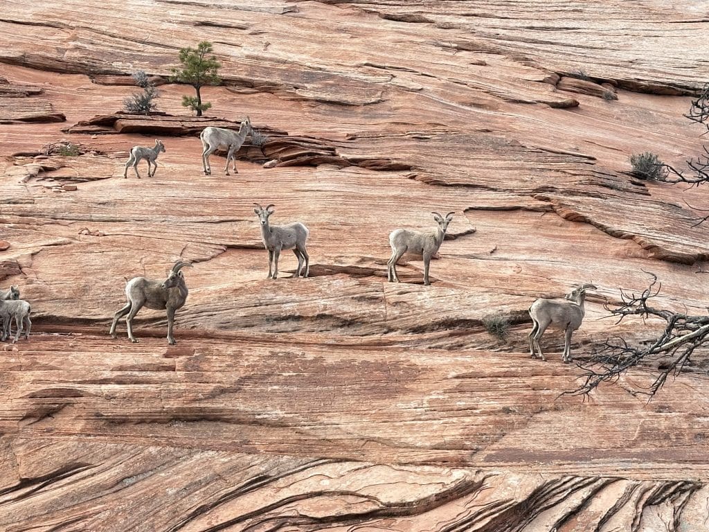
To name a few of the roughly 70 species of mammals, there are mountain lions, bobcats, coyotes, gray fox, mule deer, beaver, and porcupine. Even though some animals are nocturnal, you may see animal scat and tracks along trails to Emerald Pools and Angels Landing. Mammals – Zion National Park (U.S. National Park Service)
There are 291 species of birds in the park, including the California condor, Mexican spotted owl, Gambel’s quail, greater roadrunner, and wild turkey. Birds – Zion National Park (U.S. National Park Service)

There are also 37 species of reptiles and amphibians, and eight species of fish. Animals – Zion National Park (U.S. National Park Service)
Lodging and Hotels
Zion Lodge, with 76 hotel rooms, six suites, and 40 cabins, is the only lodge inside the park. The main lodge has an indoor restaurant, a seasonal outdoor snack bar, and a gift shop. Lodging – Zion National Park (U.S. National Park Service) To make reservations, visit https://www.zionlodge.com.
But don’t worry about food options. The town of Springdale, adjacent to the park’s south entrance, has hotels, restaurants, galleries, shops, and tour guides.
Our hotel, Cable Mountain Lodge, in Zion Canyon Village, is a great alternative to the park lodge. We enjoyed our suite and the lodge grounds, and its proximity to the park entrance.

We left our car at the lodge, didn’t have to wait in the long vehicle line to enter the park, and didn’t have to hunt for a hard-to-find parking spot. It was a breeze to walk to the park entrance and then catch a shuttle.
Zion Canyon Village has a market, pub, breakfast and coffee shop, and gift shop. There is an outfitter where you can rent bikes and waders for The Narrows. Zion Canyon Brew Pub had delicious bar food; I enjoyed its elk burger.
The eateries in Springdale range from bar and grills to nice restaurants. I suggest Dulivia Ristorante Italiano or Switchback Grill for dinner, and Bumbleberry Bakery for breakfast.
Campgrounds in Zion National Park
There are three campgrounds in the park, but one, South Campground, is currently closed for long-term rehabilitation. Campgrounds in Zion – Zion National Park (U.S. National Park Service)
To make reservations for Watchman Campground, near the visitor center, or Lava Point Campground, on north end of park, visit https://www.recreation.gov.
Check out my other national park stories, like Love Geology? 15 Ways to Explore Petrified Forest – Travel Like A Tourist.